(World Geography) The Drainage System And Landforms - Drainage Pattern, Types of Streams
WORLD GEOGRAPHY
Concepts of Geography, Natural Resources
THE DRAINAGE SYSTEM AND LANDFORMS
STREAMS
The drainage system is an integrated system of
tributaries and a trunk stream which collects and funnels surface
water to the sea, lake or some other body of water. The total area
that contributes water to a single drainage system is known as a
drainage basin. This is a basic spatial geomorphic unit of a river
system, Thus, river basins are natural units of land.
Types of Streams
1. The Antecedent or Inconsequent Drainage: The rivers that existed before the upheaval of the Himalayas and cut their courses Southward by making gorges in the mountains are known as the antecedent rivers. The Indus, Satluj, Ganga, Sarju (Kali), Arun (a tributary of Kosi), Tista and Brahmaputra are some of the important antecedent rivers, originating from beyond the Greater Himalayas.
2. Consequent Rivers: The rives which follow the general direction of slope are known as the consequent rivers. Most of the rivers of peninsular India are consequent rivers. For example, rivers like Godavari, Krishna and Kaveri, descending from the Western Ghats and flowing into the Bay of Bengal, are some of the consequent rivers of Peninsular India.
3. Subsequent Rivers: A tributary stream that is eroded along an underlying belt of non-residents rock after the rain drainage pattern (consequent river) has been established is known as a subsequent river. Due to the northward slope of the Peninsular towards the Grate Plains, the rivers originating from the Vindhyan and the Satpura ranges flow northward into the Ganga system. The Chambal, Sind, Ken, Betwa, Tons and Son meet the Yamuna and the Ganga at right angles. They are the subsequent drainage of the Ganga drainage system.
4. Superimposed, Epigenetic (Discordant) or Superinduced Drainage: It is formed when a stream with a course originally established on a cover of rock now removed by erosion, so that the stream or drainage system is independent of the newly exposed rocks and structures. In other words, it is a drainage pattern which exhibits discordance with the underlying rocks structure because it originally developed on a cover of rocks that has now disappeared due to denudation. Consequently, rivers direction relate to the former cover rocks and, as the latter were being eroded, the rivers have been able to retain their courses unaffected by the newly exposed structures. The stream pattern is thus superposed on, or placed on, ridges or structure features that were previously buried. The Damodar, the Subarnarekha, the Chambal, the Banas and the rivers flowing at the Rewa Plateau present some good examples of superimposed drainage.
DRAINAGE PATTERN
A geometric arrangement of streams in a region; determined by slope, differing rock resistance to weathering and erosion, climate, hydrologic variability, and structural controls of the landscape is known as a drainage pattern. In other words, drainage pattern refers to a design which a river and its tributaries form together, from its source to its mouth. The factors controlling the pattern of drainage in a region include the topography, slope, structure control, nature of rocks, tectonic activities, supply of water, and above all, the geological history of that region.
In India, the following types of drainage patterns are found:
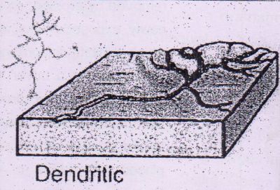
1. Dendritic Drainage: A term used for drainage which is branching, ramifying or dichotomising, thereby giving the appearance of a tree. Thus, a dendritic pattern develops in a terrain which has uniform lithology, and where faulting and jointing are insignificant; e.g., massive crystalline rocks or thick plains consisting of clays. Most of the rivers of the Indo-Gangetic Plains are of dendritic type. The term dendritic, coined by I.C. Russel(1898), is used to denote the most common type of drainage pattern and is a distinctive feature of the regions having horizontally bedded sedimentary rocks or massive igneous rocks.
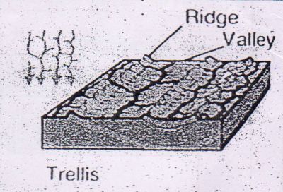
2. Trellis Drainage: Trellis is a rectangular pattern formed where two sets of structural controls occurs at right angles. In a trellis pattern, the river forms a net like system and the tributaries flow roughly parallel to each other. The old folded mountains of the Singhbhum (Chotanagpur Plateau) have a drainage of trellis pattern.
3. Barbed Pattern: A pattern of drainage in which theconference of a tributary with the main river is characterised by a discordant junction-as if the tributary intends to flow upstream and not downstream. This pattern is the result of capture of the main river which completely reverses its direction of flow, while the tributaries continue to point in the direction of former flow. The Arun River (Nepal), a tributary of the Kosi is an interesting example of barbed drainage pattern.
4. Rectangular Drainage: The drainage pattern marked by right-angled bends and right-angled junctions between tributaries and the main stream is known as rectangular drainage. It differs from the trellis pattern in so far as it is more irregular and its tributary stream are neither as long, nor parallel as in trellis drainage. A typical example of this drainage pattern is found is the Vindhyan Mountains of India.
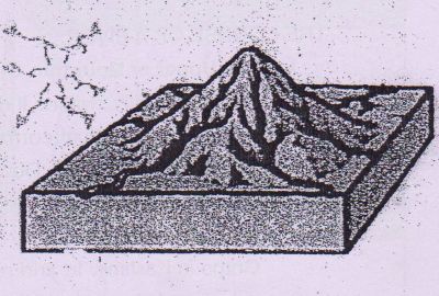
5. Radial Pattern: It is a pattern characterised by outflowing rivers, away from a central point, analogous with the spokes of a wheel. It tends to develop on the flanks of a dome or a volcanic cone. A good example of a radial drainage pattern is provided by the rivers originating from the Amarkantak mountain. Rivers like Narmada, son and Mahanadi originating from Amarkantak Hills flow in different directions and are good Examples of radial pattern. Radial drainage pattern are also found/in the Girnar Hills (Kathiawar, Gujarat), and Mikir Hills of Assam.
6. Annular Pattern: In this drainage pattern, the subsequent streams follow curving or arcuate courses prior to joining the consequent stream. This results from a partial adaptation to an underground circular structure; a dome like igneous intrusion (batholith). The subsequent streams, find it easier to erode the concentric, less resistant strata. This is not a very common drainage pattern in India. Some examples of this are however found in Pithoragarh (Uttarakhand) Nilgiri Hills in Tamil Nadu and Kerala.
7. Parallel Drainage: The drainage pattern in which the rivers flow almost parallel to each other is known as parallel drainage. The small and swift rivers originating in the Western Ghats and discharging their water into the Arabian Sea provide a good example of parallel drainage pattern in India.
8. Deranged pattern: This is an uncoordinated pattern of drainage characteristic of a region recently vacated by an ice-sheet. This probably due to the irregularities produced by glacially deposited materials, e.g. kame and Kettle, and by the fact that there has been insufficient time for the drainage to become adjusted to the structures of the solid rocks underlying the glacial drift. The picture is one of numerous water courses, lakes and marshes; some inter-connected and some in local drainage basins of their own. This type of drainage is found in the glaciated valleys of Karakoram.
data-matched-content-ui-type="image_card_stacked"
Site Search
→ यूपीएससी वन टाइम रजिस्ट्रेशन (OTR)
→ एनसीईआरटी (NCERT Books)
→ IAS/IFoS Prelims Result 2023
→ IAS Exam Dates - 2024

UPSC Mains Exam Syllabus
» Indian Language, English & Essay
Books & Exam Papers
» Booklist for IAS Examination
» Previous Year Prelims GS Papers
» Previous Year Mains GS Papers
Download IAS Planner
General FAQs and Information about
UPSC Civil Services Examination
IAS Planner Android App
→ Download Now! ←
Go to Monthly Archive
Useful Tips & Articles
तैयारी कैसे करें? |
EXAM SUBJECTS |
STUDY RESOURCESDownload Free eBooks
|